Drone Roof Inspection for Hail Claims: What It Shows
A drone captures a complete, time-stamped view of a hail-struck roof — but it can't confirm bruising by itself. Here's what aerial imagery documents, what still requires a physical inspection, and how both fit an appraisal record.
By Marshall Smith, IAUA CPAU Certified Insurance Appraiser · Published August 19, 2026 · 7 min read · Filed under Claim Documentation
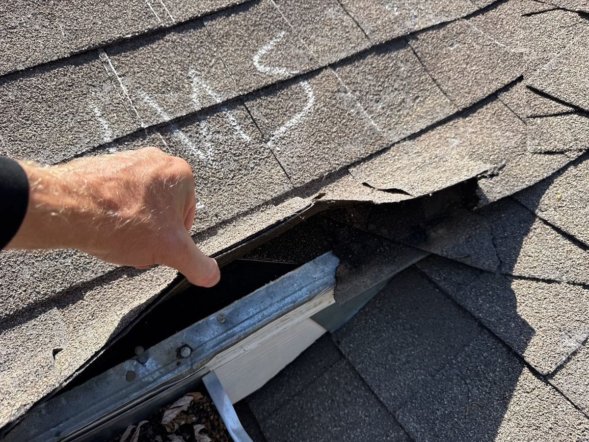
A drone roof inspection documents the overall condition of every slope, the density and distribution of surface impacts, and creates a high-resolution, time-stamped visual record that anyone reviewing the claim can see for themselves. What it cannot do is confirm, on its own, that a given mark is hail bruising rather than blistering, foot traffic, or manufacturing defect — that confirmation still comes from a hands-on inspection and test squares. Aerial imagery is a documentation tool that strengthens the evidence record; it is not a substitute for the physical examination that hail claims ultimately turn on.
If you understand that division of labor before an inspector ever arrives, you'll know what you're looking at when you review the images, and you'll understand why a thorough appraiser wants both the aerial view and the close-up view.
What aerial imagery is actually good at documenting
The single biggest advantage of a drone is coverage. A camera flown in a consistent grid pattern captures every slope of a roof at the same resolution and from a predictable angle, including steep pitches, multi-story sections, and areas that are unsafe or impractical to walk. On a large or complex roof, that completeness matters — gaps in documentation are one of the most common reasons two inspection reports on the same roof disagree.
Aerial photography is also strong at showing distribution. Hail rarely strikes a roof uniformly. It concentrates on the slopes facing the storm's approach and thins out on sheltered elevations. High-resolution overhead and oblique images make that pattern visible across the whole structure at once, which is exactly the kind of context a reviewer needs to distinguish storm-related impacts from scattered, random marks.
Finally, drone imagery is inherently documentary. Modern flight logs and image metadata carry date, time, and location information, so the images are anchored to a specific inspection. That time-stamping is valuable in any dispute where the timeline of damage is a live question. It's the same principle behind keeping your own dated photographs, just captured systematically from the air.
How a Part 107 flight is flown over a damaged roof
Commercial drone flights for property work are governed by the FAA's Part 107 rules, which is why the pilot's certification matters. A certified operator plans the flight, confirms the airspace is clear of restrictions, and flies within the required visual and altitude limits. On a roof inspection, that usually means a combination of a top-down orthographic pass — straight-down images that can be stitched into a measurable overview — and lower, angled "oblique" passes that show the texture of each slope.
Good aerial documentation is methodical rather than opportunistic. The goal is repeatable coverage: consistent overlap between frames so no section is missed, consistent altitude so scale stays comparable, and enough resolution that individual impact marks, granule loss, and mat exposure are visible when the images are enlarged. When the flight is done well, the resulting image set reads like an organized survey of the roof, not a handful of snapshots. You can see more about how these flights are conducted on our drone inspections for insurance claims page.
Reading hail evidence from the air
On composition shingles, hail typically shows as a pattern of impacts where granules have been knocked loose, exposing the darker asphalt mat underneath. From altitude, a dense field of those impacts on the storm-facing slopes stands out clearly, and the contrast is often easier to see across a whole slope in one frame than it is standing next to it.
On metal roofs, panels, vents, and flashing, aerial imagery captures denting and displacement well, especially on soft metal accessories like turbine vents, gutters, valley metal, and roof caps — components that frequently register hail even when the primary roofing is more resistant. On tile, aerial views help locate cracked, chipped, or displaced tiles across expansive roofs that would take a long time to walk.
What the imagery gives you is a map: where the impacts are concentrated, how dense they are, and whether the pattern is consistent with a directional storm event. That map is what makes the close-up work efficient and defensible, because it tells everyone where to look and why.
Why the drone doesn't replace boots on the roof
Here is the honest limitation. A photograph — even a very sharp one — shows the surface. Confirming hail damage on a shingle often requires touch: pressing on a suspected impact to feel whether the mat is bruised and soft underneath, checking whether granule loss corresponds to a true fracture rather than surface wear, and ruling out look-alikes such as blistering, mechanical damage, or normal aging. Those are tactile and dimensional judgments that a camera cannot make for you.
Measurement is another boundary. The industry-standard method for quantifying hail damage is the test square — typically a marked ten-foot-by-ten-foot area on each slope where every impact is counted and documented at close range. A test square establishes a defensible impact-density figure, which is central to determining whether a slope, or the whole roof, meets the threshold for replacement. Drones inform where to place those squares; they don't replace the count itself.
Underlayment, decking condition, soft-metal denting depth, and the interior consequences of a compromised roof — none of these are fully knowable from the air either. This is why aerial imagery and physical inspection are described as complementary rather than competing methods.
Pairing aerial images with test squares and ground photos
The strongest documentation records combine three layers, and they reinforce one another. The aerial set establishes the whole-roof context and slope-by-slope distribution. The physical test squares, photographed close-up with a measurement reference in frame, establish impact density and confirm the nature of the damage. Ground-level photographs tie in the soft-metal collateral — dented gutters, downspouts, screens, fascia, and painted surfaces — that helps corroborate a storm event.
When those layers agree, the record is coherent: the aerial map shows a directional pattern, the test squares confirm hail bruising within that pattern, and the collateral damage is consistent with the same event. That kind of internally consistent evidence is what tends to narrow disagreements. Our guide to documenting a Texas hail roof claim walks through how these pieces fit together at the ground level.
Where aerial documentation fits in the appraisal record
If a claim reaches an impasse over the extent of hail damage, the appraisal clause in most property policies provides a structured, agreed-upon way to resolve it. Each side names a competent, independent appraiser; if the two appraisers can't agree, a neutral umpire decides the disputed points. Appraisal decides the amount of loss — the scope and value — not questions of coverage.
Within that process, aerial imagery functions as part of the exhibit set. It gives both appraisers, and an umpire if one is needed, the same clear visual reference for the roof's overall condition, which reduces the room for two reports to describe the same roof in incompatible ways. Combined with test-square data and a line-item estimate, it supports a scope of loss that reflects what is actually on the roof. You can read more about how hail disputes move through this framework on our hail damage insurance appraisal page.
Getting your property ready for an aerial roof inspection
You don't need to do much, but a few steps help produce a clean image set:
- Clear the roof and yard where you can. Remove obvious debris, and note anything that has already been repaired or covered so it isn't mistaken for undamaged roofing.
- Keep your own dated photos. If you took ground-level pictures right after the storm, keep them organized. They complement the aerial record and help anchor the timeline.
- Gather your paperwork. Your policy, the declarations page, any inspection reports or estimates already produced, and correspondence about the claim all give the inspector context.
- Note weather and roofline concerns. Point out slopes you're worried about, additions of different roofing age, and any interior signs like ceiling staining.
A few questions property owners still ask
Does a drone inspection replace the insurance company's inspection? No. It documents the roof independently and thoroughly. Both sides may still conduct their own inspections; the aerial record simply gives everyone a shared, detailed reference.
Can aerial images prove when the hail fell? They prove the condition of the roof on the date of the flight. Establishing the date of loss is a separate question that draws on time-stamped photos and other records rather than the imagery alone.
Is a drone safe for a fragile tile or aging roof? Yes — that's one of its strengths. Because the drone doesn't touch the surface, it documents brittle tile and steep or unstable roofs without adding foot traffic that could cause damage.
Talk it through before your next step
If you're weighing whether aerial documentation would strengthen your hail claim, Marshall Services offers a free consultation to discuss your situation as a neutral, independent appraiser and umpire. Call 972-322-0752 to talk it through.