Drone Roof Imagery for Hail & Wind Appraisal
Licensed aerial imagery captures roof hail and wind evidence a ground inspection can miss — and turns it into a documented scope of loss the appraisal panel can work from.
By Marshall Smith, IAUA CPAU Certified Insurance Appraiser · Published September 1, 2026 · Updated October 15, 2026 · 8 min read · Filed under Claim Documentation
Our work includes insurance appraisal services, hail damage insurance appraisal, and wind damage insurance appraisal.
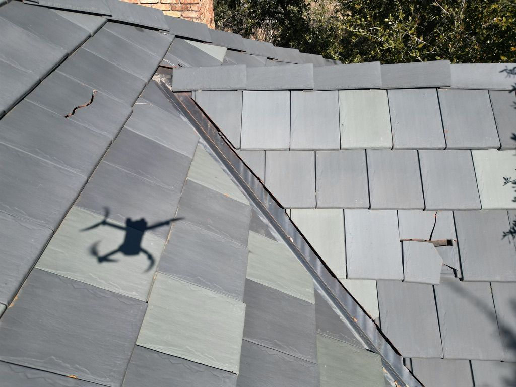
Licensed drone imagery documents roof hail and wind damage by capturing high-resolution, geotagged, time-stamped photographs of every slope — including steep or high roofs a person cannot safely walk — so that each area of impact, lifted shingle, or displaced material becomes a specific, locatable line item in the scope of loss. In appraisal, that visual record is what lets two independent appraisers, and an umpire if needed, measure and price the same damage against the same evidence rather than against competing recollections. The drone does not decide anything; it makes the roof reviewable.
Below is what that imagery actually captures, how it becomes a scope of loss, and how it functions when appraisers read a roof differently.
What FAA Part 107 certification actually means
Part 107 is the Federal Aviation Administration's certification for commercial drone operation. A person flying a drone for a paid inspection is required to hold it, and earning it means passing an FAA knowledge exam covering airspace rules, weather, flight restrictions, and safe operating procedures. It is not a marketing badge. It is the difference between a lawful commercial flight and an uncertified one.
For a property owner, the certification matters for two practical reasons. First, imagery gathered on a properly conducted, certificated flight rests on a defensible foundation — the operator was authorized to be in the air and to document the property. Second, a certified operator understands where and when a flight can happen: controlled airspace near airports, altitude limits, and conditions that would compromise image quality. Marshall Services holds FAA Part 107 certification, and every aerial inspection is flown under it.
What a drone sees that a ground look can miss
A roof inspection done from a ladder or from the ground has a built-in blind spot: the inspector can only document what is reachable and visible from the edge. Field slopes, ridge caps, the far side of a hip, and the high sections of a two- or three-story home often go under-recorded not because the damage isn't there but because no one could get to it safely.
A drone flies the entire roof plane. Flown correctly, it produces:
- Overhead orthographic images that show slope layout, direction, and the distribution of impacts across the whole surface.
- Close-range oblique shots of individual shingles, showing hail bruising, mat fracture, granule loss, and the crushed or torn edges wind leaves behind.
- Detail on vents, flashing, and metal accessories — soft aluminum that dents where hail lands, giving an independent read on impact density.
- Wide context frames placing the roof in relation to trees, neighboring structures, and the direction damage runs across the property.
That range matters because hail and wind leave different signatures. Hail tends to leave scattered, roughly circular impact points with directional bias depending on how the storm tracked. Wind lifts, creases, and removes material along edges and ridges and in the direction it blew. Aerial imagery captures both patterns across the full roof rather than sampling one accessible corner, which is exactly the completeness a hail damage appraisal or a wind damage appraisal depends on.
Getting the whole roof on the record — not just the damaged slope
A common documentation gap in roof disputes is a record that shows the damage but not the roof. If only the visibly hit slope is photographed, there is no way to establish scale, count, or distribution. A strong aerial record documents every slope, including undamaged ones, because the absence of damage in one area is itself information: it helps distinguish storm-created damage from ordinary wear, foot traffic, or manufacturing defects.
The images are also geotagged and time-stamped by the drone's onboard systems, which anchors them to a location and a moment. Combined with a consistent naming or mapping convention, that lets anyone reviewing the file connect a specific photograph to a specific spot on a specific slope. When the scope later says "north-facing field slope, hail impacts," the reviewer can go straight to the frames that show it.
Tying the imagery to the storm without inventing facts
Photographs show condition. They do not, on their own, prove when a storm hit or how large the hail was. Those questions belong to the weather record, and the honest way to handle them is to keep the two kinds of evidence separate and let each do its own job.
A property owner should pull the historical weather information available for their address and date range and let a professional correlate documented conditions with the physical damage on the roof. What the drone imagery contributes to that correlation is the observable evidence — impact size relative to a scale reference, directional pattern, freshness of the fractures — that a qualified reviewer can weigh against the weather record. Neither the operator nor the appraiser should assert a specific wind speed or hail diameter as fact unless it comes from a documented, attributable source. If the reading cannot be sourced, it does not go in as an external fact. The photographs stand on what they actually show.
Turning photographs into a line-item scope of loss
Appraisal settles the amount of loss, and the amount of loss is built line by line. Aerial imagery feeds that process directly. From a complete image set, an appraiser can measure roof dimensions, count and locate impacts, identify affected slopes, and specify the components involved — shingles, underlayment, ridge cap, flashing, vents, drip edge — each of which becomes a discrete line with a quantity and a price, typically in estimating software such as Xactimate.
The value is that the estimate is no longer an assertion. Every line traces back to a photograph a reviewer can open. That traceability is what makes a scope persuasive inside appraisal: the two appraisers are not arguing over whether damage exists, they are pricing documented items. Photo-backed documentation is the foundation of a defensible position, a point covered in more depth in our guide to hail damage roof claims in Texas.
Steep, high, and fragile roofs where drones earn their keep
Safety and access are not incidental benefits — on many roofs they are the whole reason aerial documentation exists. Steep-slope roofs, three-story homes, tile, slate, and aged or storm-weakened decking can be genuinely dangerous or impossible to walk without risking injury or causing new damage. Walking a brittle tile roof to inspect it can crack tiles that were intact.
A drone removes that trade-off. It documents the high ridge, the fourth slope no ladder reaches, and the fragile surface no one should stand on, all without a person leaving the ground. For commercial and multi-family buildings with large, complex roof systems, that reach is the difference between a partial record and a complete one — which is why aerial work features on both our commercial and drone inspection service pages.
When two appraisers read the same roof differently
In appraisal, each side selects its own independent appraiser. The two review the loss and try to agree on the amount. Where they disagree — and roof scope is one of the most common sticking points — the items in dispute go to a neutral umpire, who decides only the contested items.
Aerial imagery changes the character of that disagreement. Instead of two people describing a roof from memory or from incomplete notes, both work from the same complete, geotagged, time-stamped record. The umpire, brought in to resolve what the appraisers could not, has an objective visual reference for each disputed slope or component rather than dueling narratives. Whether the disagreement is about how many slopes are affected, whether marks are storm-created or wear, or the extent of a wind-lifted section, the images give the panel something concrete to measure against.
It is worth being precise about what this does and does not settle. Appraisal — and the imagery that supports it — determines the amount of loss. Whether a particular loss is covered at all is a separate question decided under the policy by the carrier and, where the parties disagree, by a court. The drone documents the damage; it does not decide coverage, and neither the appraisers nor the umpire do.
Talk it through before your next roof inspection
If a hail or wind event has damaged your roof and the valuation is in question, documented aerial evidence can strengthen the record before appraisal begins. Marshall Services offers a free consultation to discuss your situation, how a Part 107 drone inspection fits your claim, and whether appraisal is the right path. Call 972-322-0752 to speak with a certified appraiser and umpire.
What this article covers
This article explains how FAA Part 107 drone imagery is captured and used as evidence in a roof hail or wind appraisal — what is flown, what the imagery has to show, and how it is challenged. The firm's own announcement of the service, with the date it was made, is the press release on FAA Part 107 drone inspections.
Frequently Asked Questions
Is a drone roof inspection accepted as evidence in the appraisal process?
Yes — geotagged, time-stamped aerial photographs are treated the same as any other credible documentation of the property's condition, and both appraisers and an umpire can review them. Their weight comes from completeness and traceability: a full image set that ties each observation to a specific slope gives the panel an objective reference for measuring and pricing the amount of loss, which is what appraisal decides.
Does drone imagery prove what caused the roof damage?
Drone imagery documents the condition and pattern of damage, not the cause by itself. Photographs can show impact size against a scale, directional patterns, and how fresh fractures appear, and a qualified reviewer can weigh that against a documented weather record for the date and location. Causation is a professional conclusion drawn from combined evidence, not something a single photograph establishes on its own.
Do I need a Part 107 pilot, or can I photograph my own roof?
You can photograph your own roof from the ground or a ladder, but any drone flight performed as part of a paid inspection service must be flown by an FAA Part 107 certificate holder. A certified operator also understands airspace restrictions, altitude limits, and the conditions that produce usable imagery, so the resulting record rests on a lawful and defensible foundation.
Can a drone inspection tell me whether my roof damage is covered?
No. A drone inspection documents the amount and extent of damage; it does not determine coverage. Whether a loss is covered is a separate determination made under your policy by the carrier and, where the parties disagree, resolved by a court — never by the appraisers or the umpire. Check your own policy for its terms, and use the inspection to establish what the damage actually is.
What makes a drone image set complete enough for appraisal?
A complete set documents every roof slope — damaged and undamaged — plus close-range detail of shingles, flashing, vents, and ridge caps, with overhead and oblique angles and a consistent way to locate each frame on the roof. Documenting undamaged areas matters too, because it helps distinguish storm-created damage from ordinary wear and gives the panel the full picture rather than a single corner.